April 24, 2018
By: Michael Feldman
After four years of development, the US Department of Energy (DOE) is releasing the Energy Exascale Earth System Model (E3SM), a computational platform for performing high-resolutions simulation of the weather and other earth systems.
ES3M is described as “the first end-to-end multi-scale Earth system model” coupling simulations of the atmosphere, land, and ocean (including sea ice). As such, it will provide forecasting on how these various elements interact. The software will also be used to study the interplay between humans acivities and natural processes. In particular, ES3M can model how man-made global climate change will impact the various earth systems.

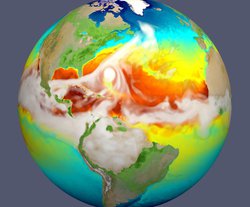
Simulation of sea surface temperatures during passage of hurricane in the Atlantic.
Specifically, E3SM was conceived to advance earth system modeling on three fronts:
- Improving the resolution of earth system processes by developing new processes in the model, increasing the model resolution, and by enhancing computational performance.
- Providing a more realistic model of the interactions between human activities and natural processes, especially as they impact US energy demand.
- Implementing ensemble modeling for the purpose of quantifying uncertainties in the simulations and forecasts.
Of course, the DOE has had earth system models in the past, but E3SM supports more complex simulations and runs them at higher resolutions. To accomplish this, it’s designed to take advantage of the greater computational power of exascale systems. All of which makes it possible to answer more granular questions about things like droughts, sea level rises, hurricane intensity, and ocean circulation. The reason this matters to the DOE is because all of these processes will have a profound effect on energy needs, as well as the production of solar, wind and hydroelectric resources.
“This model adds a much more complete representation between interactions of the energy system and the earth system,” explained David Bader, Lawrence Livermore National Laboratory (LLNL) scientist and lead of the E3SM project. “The increase in computing power allows us to add more detail to processes and interactions that results in more accurate and useful simulations than previous models.”
At this point, ES3M is running on pre-exascale DOE supercomputers, but the software promises to show its true value once exascale machines become available. The first such system, Aurora, is scheduled to be deployed at Argonne National Lab in 2021. Between 2022 and 2023, at least two more DOE exascale supercomputers are slated to come online.
“Today one of our biggest successes is the performance of the model on prototype exascale computers, where on a per-node basis, the model runs faster and uses less power than on conventional architectures,” explained Mark Taylor, Chief Computational Scientist for ES3M at Sandia National Laboratories. “This is due to our work in scalability, vectorization, threading, and software engineering.”
According to Todd Ringler, of Los Alamos National Lab, there is no shortage of problems to tackle. One that the Los Alamos team focused on is the danger of an abrupt rise in sea level due to widespread melting of sea and land ice. “Take the Arctic, for example,” said Ringler. “It is changing rapidly and this presents new opportunities and new security risks. This new modeling capability, particularly the new approaches that we developed for the ocean and sea-ice systems will be critical for predicting the how, when and why of the changing Arctic.”
The development of E3SM has involved more than 100 scientists and software engineers at multiple DOE Laboratories plus a number of universities. The energy labs include Argonne, Brookhaven, Lawrence Livermore, Lawrence Berkeley, Los Alamos, Oak Ridge, Pacific Northwest and Sandia. E3SM also drew from collaborations with the Exascale Computing Project, Scientific Discovery Through Advanced Computing (SciDAC) effort, and the Climate Model Development and Validation (CMDV) work, as well as a number of other DOE-sponsored earth science programs.
The software, which is being maintained as a GitHub project, includes code, documentation, and output from an initial set of benchmarks. For in-depth information on the model and the associated simulation tools, as well as future research directions, check out the E3SM website.